
Every year it seems for as long as I can remember property taxes have increased.
Did you know that doesn’t have to be the case?
In this article you’ll learn if you qualify to save hundreds if not thousands of dollars EVERY YEAR!!
For the rest of your life!
And yes, Clallam County has a seniors property tax deduction or exemption. But it depends if you qualify.
The county has a variety of tax relief programs for homeowners.
So if you are a senior citizen 61 years old or older on December 31 of the filing year (no age requirement for disabled persons), the owner and occupant of a single family dwelling, mobile home, or one unit in multiple-unit housing, and with a combined disposable income of $46,000 or less beginning 2024, you may be entitled to a property tax discount. If you believe you qualify for this benefit, we can help you receive this fast. Schedule an appointment with us today and we will help you cut through the red tape.
Disabled veterans with an 80% service-connected disability may also be entitled to a property tax deduction. You must own and occupy your residence and your combined disposable income must not exceed $46,000 starting 2024.
Tax due dates can be less burdensome if you qualify for a discount on your property tax payment. Let’s help you get this benefit you deserve. Schedule an appointment with us today.
About Clallam Count
Clallam County is a county in the U.S. state of Washington. As of the 2020 census, the population was 77,155, with an estimated population of 77,805 in 20221https://en.wikipedia.org/wiki/Clallam_County,_Washington.
The name is a Klallam word for “the strong people”. Located on the Olympic Peninsula, the county is south from the Strait of Juan de Fuca, which forms the Canada–US border, as British Columbia’s Vancouver Island is across the strait.
In the 2010 census, Clallam County had 35,582 housing units at an average density of 20.5 units per square mile (7.9 units/km2).
The County has several fairgrounds, campsites, and parks for family outdoor activities.
Campground/Overnight Facility
Dungeness Recreation Area
The Dungeness Recreation Area is a 216-acre park great for hiking and biking activities. It is located 15 miles east of Port Angeles, Washington. You will find 66 forested campsites along the two loops within the park.
You can reserve large group site for your organizational activities. There will be picnic area and cookout grills for your tribe.

Salt Creek Recreation Area
Salt Creek Recreation Area offers various activities for visitors who love to go hiking, bird watching, tide pooling, or even scuba-diving in one day.
Located 17 miles west of Port Angeles, the 196-acre Salt Creek Recreation Area features 49 RV sites and 43 tent sites.
You will also see some remnants of the WWII Camp Hayden, preserved onsite with two concrete bunkers that used to house 16-inch cannons.
The campsites are nestled in a coastal forest and offer unforgettable views of the Strait of Juan de Fuca.
Salt Creek Recreation Area is open year-round. You can take advantage of fewer crowds in the fall, winter, and spring seasons.


Camp David Jr.
Camp David Jr. is the perfect place for group activities. You can hold adult group retreats, educational or recreational camps, family reunions, or weddings here.
Located 30 miles west of Port Angeles, the Camp has ten heated cabins and a lodge replete with antler chandeliers, a commercial kitchen, refurbished murals, table seating for one hundred, as well as meeting areas, indoor recreation room, and a central bathroom.
There’s also a lake in Camp David Jr. where you can go out for a camp canoe, fish, or a refreshing afternoon dip.
Mount Angeles
Mount Angeles is located just south of Port Angeles, Washington in the Olympic National Park2https://en.wikipedia.org/wiki/Mount_Angeles. It is the highest peak in the Hurricane Ridge area. The summit, which offers panoramic views of the Strait of Juan de Fuca and many of the peaks of the interior Olympic Mountains can be climbed from the Klahane Ridge trail.


Cape Flattery
Cape Flattery is the northwesternmost point of the contiguous United States3https://en.wikipedia.org/wiki/Cape_Flattery. It is in Clallam County, Washington on the Olympic Peninsula, where the Strait of Juan de Fuca joins the Pacific Ocean. It is also part of the Makah Reservation, and is the northern boundary of the Olympic Coast National Marine Sanctuary. Cape Flattery can be reached from a short hike, most of which is boardwalked. The westernmost point in the contiguous United States is at Cape Alava, south of Cape Flattery in Olympic National Park. However, the westernmost tip of Cape Flattery is almost exactly as far west as Cape Alava, the difference being approximately 5 seconds of longitude, about 360 feet (110 m), at high tide and somewhat more at low tide.


Dungeness Spit
Dungeness Spit is a sand spit jutting out approximately 5 miles (8 km) from the northern edge of the Olympic Peninsula in northeastern Clallam County, Washington into the Strait of Juan de Fuca4https://en.wikipedia.org/wiki/Dungeness_Spit. It is the longest natural sand spit in the United States. The spit is growing in length by about 15 feet (4.6 m) per year. The body of water it encloses is called Dungeness Bay.


Elwha River
The Elwha River is a 45-mile (72 km) river on the Olympic Peninsula in the U.S. state of Washington. From its source at Elwha snowfinger in the Olympic Mountains, it flows generally north to the Strait of Juan de Fuca. Most of the river’s course is within the Olympic National Park5https://en.wikipedia.org/wiki/Elwha_River.


Gray Wolf Ridge
Gray Wolf Ridge is a spur of the northeastern Olympic Mountains in Washington’s Olympic Peninsula. Arcing northeast from the Mount Deception – Needles – Mount Clark – Mount Walkinshaw massif, Gray Wolf Ridge is covered by alpine and subalpine forests up to the timberline, leaving the upper elevations of the ridge’s six rocky peaks vegetated only by fragile alpine meadows. The ridge and its component mountains are markedly steep, as is its primary access route, the Maynard Burn Trail (#816) of Olympic National Forest. The higher, western segment of Gray Wolf Ridge lies within the boundary of Olympic National Park6https://en.wikipedia.org/wiki/Gray_Wolf_Ridge.

Hoh River
The Hoh River is a river of the Pacific Northwest, located on the Olympic Peninsula in the U.S. state of Washington. About 56 miles (90 km) long, the Hoh River originates at the snout of Hoh Glacier on Mount Olympus and flows westward through the Olympic Mountains of Olympic National Park and Olympic National Forest, then through foothills in a broad valley, emptying into the Pacific Ocean at the Hoh Indian Reservation. The final portion of the Hoh River’s course marks the boundary between the south coastal segment of Olympic National Park and the Hoh Indian Reservation7https://en.wikipedia.org/wiki/Hoh_River.


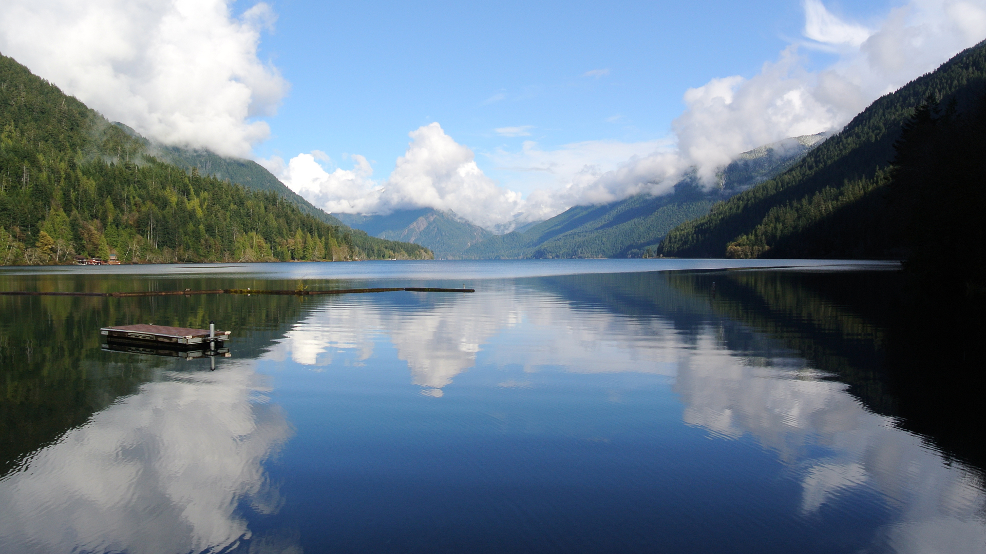
Lake Crescent
Lake Crescent is a deep lake located entirely within Olympic National Park in Clallam County, Washington, United States, approximately 17 miles (27 km) west of Port Angeles on U.S. Route 101 and nearby to the small community of Piedmont. At an official maximum depth of 624 feet (190 m) it is officially the second deepest lake in Washington (after Lake Chelan). A lake-wide bathymetric survey was performed from 2013 to 2014 by Eian Ray and Jeff Engea and the results of this survey showed the maximum depth as being 596 feet. Using GIS statistical analysis, this survey also showed the lake contains approximately 0.5 cubic miles of fresh water8https://en.wikipedia.org/wiki/Lake_Crescent.


Ozette Lake
Lake Ozette is the largest unaltered natural lake in Washington state at 29.5 km2 (11.4 sq mi). The Makah name for Lake Ozette was Kahouk meaning “large lake”. 8 mi (13 km) long and 3 mi (4.8 km) wide, Lake Ozette is contained within the northern boundary of the Olympic National Park’s coastal strip. It is 29 ft (8.8 m) above sea level and is drained by the Ozette River in the north end. At 331 feet (101 metres) deep, its bottom lies more than 300 feet (91 metres) below sea level9https://en.wikipedia.org/wiki/Ozette_Lake.


Lyre River
The Lyre River in the U.S. state of Washington flows out of Lake Crescent in the Olympic National Park and into the Strait of Juan de Fuca. Originally referred to as “singing waters” by the Indians living near it, the river was first named Rio de Cuesta by Europeans in 1790 by Gonzalo López de Haro, but was later called River Lyre after being charted by Captain Henry Kellett in 184710https://en.wikipedia.org/wiki/Lyre_River.

Seven Lakes Basin
Seven Lakes Basin is a formerly-glaciated mountain lake basin located at the headwaters of the Sol Duc River in Olympic National Park. A hiking trail to the basin is 19 miles (31 km) round trip with about 4,000 feet (1,200 m) of elevation gain. The loop trail starts by following the Sol Duc River near Sol Duc Hot Springs, traversing south past Sol Duc Falls before beginning a rapid elevation gain to eventually arrive at the High Divide separating the Hoh River valley from the Sol Duc valley, with views across the Hoh Valley to Mt. Olympus to the south11https://en.wikipedia.org/wiki/Seven_Lakes_Basin.


Sol Duc Hot Springs
Sol Duc Hot Springs is a resort located in Olympic National Park, Washington state, that is best known for its soaking pools, hot tubs, and a swimming pool that are heated with the nearby hot springs. The resort is situated in a valley carved by the Sol Duc River12https://en.wikipedia.org/wiki/Sol_Duc_Hot_Springs.
.jpg\">Robert Ashworth</a>.")
.jpg\">Olympic National Park</a>.")
.jpg\">Robert Ashworth</a>.")
Sol Duc River
The Sol Duc River (also spelled Soleduck) is a river in the U.S. state of Washington. About 78 miles (126 km) long, it flows west through the northwest part of the Olympic Peninsula, from the Olympic Mountains of Olympic National Park and Olympic National Forest, then through the broad Sol Duc Valley. Near the Pacific Ocean the Sol Duc River joins the Bogachiel River, forming the Quillayute River, which flows about 4 miles (6.4 km) to the Pacific Ocean at La Push. Although the Quillayute River is short, its large tributary rivers—the Sol Duc, Bogachiel, Calawah, and Dickey Rivers—drain the largest watershed of the northern Olympic Peninsula, 629 square miles (1,630 km2). The Sol Duc’s watershed is the largest of the Quillayute’s tributaries, at 219 square miles (570 km2)13https://en.wikipedia.org/wiki/Sol_Duc_River.


Strait of Juan de Fuca
The Strait of Juan de Fuca (officially named Juan de Fuca Strait in Canada) is a body of water about 96 miles (83 nmi; 154 km) long that is the Salish Sea’s main outlet to the Pacific Ocean. The international boundary between Canada and the United States runs down the centre of the Strait14https://en.wikipedia.org/wiki/Strait_of_Juan_de_Fuca.


Tatoosh Island
Tatoosh Island is a small island and small group of islands about 0.5 miles (0.8 km) offshore (northwest) of Cape Flattery, which is on the northwestern tip of the Olympic Peninsula in Washington. Tatoosh is the largest of a small group of islands also often referred to as simply “Tatoosh Island”, which are almost as far west as Cape Alava, which is about 15 miles (24 km) to the south and the westernmost point in the contiguous 48 states. The islands are part of the Makah Reservation and a part of Clallam County15https://en.wikipedia.org/wiki/Tatoosh_Island,_Washington.


National Protected Areas
Pacific Northwest Trail (Part)
The Pacific Northwest Trail (PNT) is a 1,200-mile (1,900 km) hiking trail running from the Continental Divide in Montana to the Pacific Ocean on Washington’s Olympic Coast. Along the way, the PNT crosses three national parks, seven national forests, and two other national scenic trails. It travels against the grain of several mountain ranges, including the Continental Divide, Whitefish Divide, Purcells, Selkirks, Kettles, Cascades, and Olympics16https://en.wikipedia.org/wiki/Pacific_Northwest_Trail.


Dungeness National Wildlife Refuge
The Dungeness National Wildlife Refuge is located near the town of Sequim in Clallam County in the U.S. state of Washington, on the Strait of Juan de Fuca. The refuge is composed of 772.52 acres (312.63 ha) which include Dungeness Spit, Graveyard Spit, and portions of Dungeness Bay and Harbor. Dungeness is one of six refuges in the Washington Maritime National Wildlife Refuge Complex17https://en.wikipedia.org/wiki/Dungeness_National_Wildlife_Refuge.


Olympic National Forest (Part)
Olympic National Forest is a U.S. National Forest located in Washington, USA. With an area of 628,115 acres (2,541.89 km2), it nearly surrounds Olympic National Park and the Olympic Mountain range. Olympic National Forest contains parts of Clallam, Grays Harbor, Jefferson, and Mason counties. The landscape of the national forest varies, from the temperate Olympic rain forest to the salt water fjord of Hood Canal to the peaks of Mt. Washington18https://en.wikipedia.org/wiki/Olympic_National_Forest.


Olympic National Park (Part)
Olympic National Park is a United States national park located in the State of Washington, on the Olympic Peninsula. The park has four regions: the Pacific coastline, alpine areas, the west-side temperate rainforest, and the forests of the drier east side. Within the park there are three distinct ecosystems, including subalpine forest and wildflower meadow, temperate forest, and the rugged Pacific coast19https://en.wikipedia.org/wiki/Olympic_National_Park.