
Every year it seems for as long as I can remember property taxes have increased.
Did you know that doesn’t have to be the case?
In this article you’ll learn if you qualify to save hundreds if not thousands of dollars EVERY YEAR!!
For the rest of your life!
Benton County offers tax relief for specific classes of individuals. As of 2023, it has eight primary programs, one of which are for senior citizens and disabled persons.
Beginning 2024, the county gives property tax discounts to senior citizens and disabled persons whose annual income does not exceed $56,000. If you own and reside in your home, including mobile homes, you may be able to get a tax reduction. You must be at least 61 years of age or, if under 61, retired because of a disability and unable to work. Schedule a short meeting with our team today and we will help you get this benefit.
If you are a veteran of the armed forces of the United States receiving compensation from the United States Department of Veterans Affairs either with a combined service-connected evaluation rating of 80% or higher or total disability rating for a service-connected disability without regard to evaluation percent, you might also be qualified for a property tax reduction. Additionally, your income should not exceed $56,000 starting 2024.
If you qualify, we will help you reduce your property tax burden.
You might want to take note that property taxes are due when the Treasurer has certifies them. This typically happens in mid to late January of each year. The taxes are late if the first half is not paid by April 30. If the first half is paid by April 30, the balance owing is late if not paid by October 31.
But don’t wait for the due date. We’ll help you cut through the red tape and receive this benefit fast. Schedule an appointment with us today.
About Benton County
Benton County is a county in the south-central portion of the U.S. state of Washington. As of the 2020 census, its population was 206,8731https://en.wikipedia.org/wiki/Benton_County,_Washington.
Based on the data from the United States Census Bureau, Benton County has a total area of 1,760 square miles (4,600 km2), of which 1,700 square miles (4,400 km2) is land and 60 square miles (160 km2) (3.4%) is water. The highest point of land elevation within the county is the summit of Rattlesnake Mountain at 3,527 feet; and the lowest point of land elevation is along the southwestern shore of Crow Butte at 265 feet (fluctuates due to level of Columbia River).
Parks
Horn Rapids Park
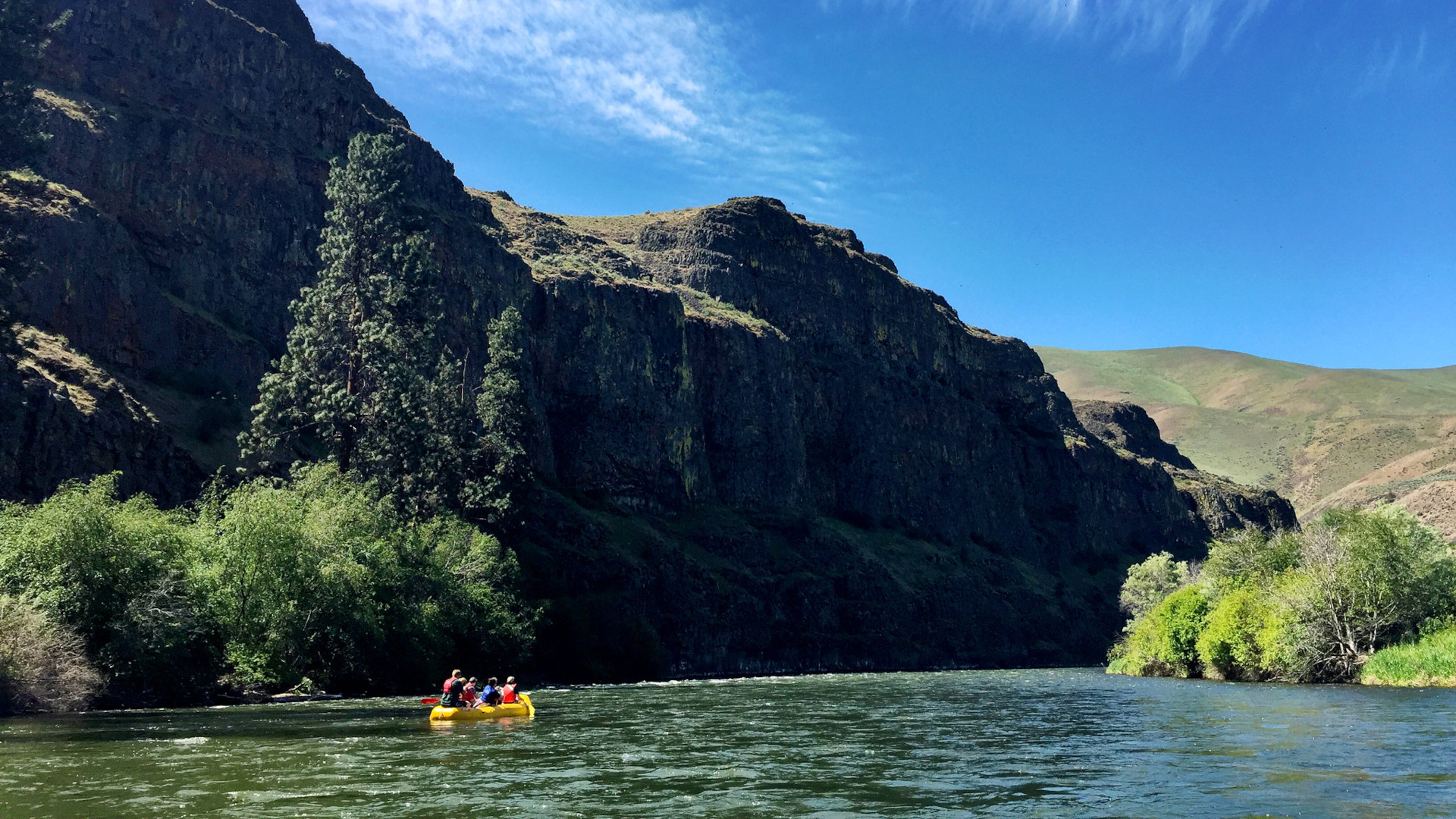
The county has several parks for all who wish to enjoy outdoor activities. You can have an overnight camping in Horn Rapids Park – an 800 acres of transitional river-to-upland shrub-steppe habitat that is accessible and relatively quiet. It is open from April 1 through October 1 each year. The park is protected by over 5 miles of Yakima River frontage on one side and the public lands on the other2https://www.flickr.com/photos/blmoregon/27692684885.


Badger Mountain Centennial Preserve
Benton’s Badger Mountain Centennial Preserve is another point of interest. It’s a perfect place for hiking, biking, and horse riding. A unique story behind it is that the place is the product of a grassroots public fundraising campaign by the Friends of Badger Mountain organization. The goals for saving Badger Mountain were to preserve views, protect upland shrub-steppe habitat, and provide for non-motorized outdoor activities. In the years since, the Preserve has been expanded to over one square mile in size and features eight miles of trails. The Preserve is one of the most visited parks in the Tri-Cities, having over 200,000 patron visits each year.


Candy Mountain Preserve
In June 2016, the county included Candy Mountain as its 10th park. A State of Washington grant, matched by funds raised in the community by the Friends of Badger Mountain, afforded the acquisition of 186 acres in Goose Gap and the upper slopes of the mountain. A parking area and multiple trails have been developed, including various interpretive and other elements.


Horse Heaven Vista
Benton County also owns the two-acre site, Horse Heaven Vista. It is essentially a viewpoint with a small paved and landscaped parking area and a modest shelter. It lies above Prosser along Highway 221 on the crest of the Horse Heaven Rim.


Horse Heaven Cemetery
In 2012, the county added Horse Heaven Cemetery to its parks portfolio. It is a two-acre decommissioned pioneer cemetery located about seven miles south of Benton City. The cemetery was established in 1893 by the Dennis family. Since the 1940s, the cemetery has not had a burial.


Rattlesnake Mountain Shooting Facility
Benton County has a shooting facility that people from various shooting disciplines will enjoy. The Rattlesnake Mountain Shooting Facility is operated on behalf of Benton County by the Tri-Cities Shooting Association. The County leases the property located between MP 8.2 and MP 9 on SR-225 jointly from Washington State and the US Bureau of Land Management.


Two Rivers Park
Considered as the county’s most developed and most visited park, Two Rivers is a bridge connecting several urban park amenities. It has a playground, various picnic sites, and 19 acres of lawn to rural open space qualities like nature trails, native habitat, and open space. The park has three sheltered lagoons, fed from over two miles of Columbia River shoreline, and the last downstream developed boat launch in the Tri-Cities.


Vista Park
Benton County also has its smallest park, the Vista Park, located in the Tri-Cities Heights neighborhood of Kennewick. It was originally developed by the Vista Junior Women’s Club in 1970. In 2015 and 2016, the county completely remodeled the park and put up a new playground, refurbished lawn, donated tree, repainted wall, and other updates.


Wallula Gap Preserve
You can also visit the county’s Wallula Gap Preserve, where a part of the Wallula Gap is found. The Wallula Gap is a large water gap of the Columbia River in the northwest United States in southeast Washington3https://en.wikipedia.org/wiki/Wallula_Gap. It cuts through the Horse Heaven Hills basalt anticlines in the Columbia River Basin, just south of the confluence of the Walla Walla and Columbia rivers. It has been recognized as a National Natural Landmark by the National Park Service as a site that provides an important illustration of the geological history of the United States.


Trails
Benton County’s interactive The Trails of Benton County4https://storymaps.arcgis.com/stories/ed4f97daa1c545f29d4017245c37ed36 is a must-see for those who love hiking, biking, and horse riding. It features the 22 trails the county offers and essential information that will make your trip more fun and safe.
Candy Mountain Summit Trail
The first on the list is Candy Mountain Summit Trail. It is a 1.8-mile, point to point trail that starts at the parking lot and goes to a converted road. For the first 0.5 miles, you will go up by 60 feet. The rest of the summit will steadily increases by 10% grade. The path is paved with gravel and is wide enough to allow passing of fellow trail-goers. Hikers, runners, bikers, and horse riders will enjoy Candy Mountain Summit Trail.


Candy Mountain Interpretive Loop
Next is Candy Mountain Interpretive Loop – an easy trail that goes to a 1.2 mile long loop. It provides hikers the enjoyment of the mountain without having to hike to the top. The path is wide and graveled with little elevation change. It’s best for hiking, running, biking, and horse riding. Access to the loop is at the Candy Mountain Preserve Trailhead parking lot.


Badger Mountain to Candy Mountain Connector Pathway
Another trail is the pathway connecting Badger Mountain to Candy Mountain. The pathway links the parking lots of the Badger Mountain Skyline Trail with the parking lot for the Candy Mountain Interpretive Trail I. You may access the pathway at the Westgate or Candy Mountain Preserve Trailhead parking lots.


Skyline Trail
After the pathway, you can explore Skyline Trail, where you begin along the western side of Badger Mountain and meander up the mountain. From there, you can connect to most of the other trails of Badger Mountain. About 0.5 miles, you can also go to the right and continue on the Langdon Trail. Otherwise, you can continue on the trail up towards the summit and towards the east, where you will have the option of connecting to the Canyon Trail or, further along, the Sagebrush Trail. Both the Canyon Trail and the Sagebrush Trail will take you to the Trailhead Park parking lot. Skyline Trail is not as steep as the other summit trail, the Canyon Trail, with more switchbacks and a more gradual ascent. Hikers, runners, mountain bikers, and horse riders can access Skyline Trail at the Westgate parking lot off of Dallas Road on the west side of Badger Mountain. Expect a 3-mile trail, with an option to continue.


Langdon Trail
The next trail is Langdon Trail that follows the south slope of Badger Mountain. It is perfect for family hiking due to its easy grade trail. Along its path, you will see seasonal beautiful wildflowers, sagebrush, and a variety of birds, beetles, and ground animals. It can be accessed from either the Westgate or Trailhead Park parking lots. But you need to hike on additional trails to access. The closest access is via the Skyline Trail beginning at the Westgate parking lot. Hikers, runners, mountain bikers, and horse riders should expect a 2.5-mile journey with an option to continue.


Canyon Trail
Canyon Trail is the steepest trail on Badger Mountain – and also the most popular. It has an average grade of 15% and an elevation gain of 800 feet to the summit. So expect a challenging hike with no shade – for a journey of 1.4 miles and an option to continue. This trail offers 3.5 feet of path width and is paved with crushed rock. It contains stairs. Once you reach the communication towers the trail links up with the Skyline Trail. Unlike the previous trails, Canyon Trail is only for hikers and runners. You can access this trail at the Trailhead Park parking lot.


Sunflower Trail
After going Canyon Trail, you can skip the stair section of Canyon Trail and go down thru Sunflower Trail. It is a very easy path that connects between Canyon Trail and Sagebrush. This means, you can go over to Canyon Trail from Sagebrush via Sunflower Trail. By this route, you can ascend to the top of Badger Mountain. Expect a journey length of 520 ft, with options to continue. Same with Canyon Trail, it is only available for hikers and runners.


Sagebrush Trail
Easier than the Canyon Trail, the Sagebrush Trail will help you find your way to the summit of Badger Mountain with less of an incline. The average slope on this trail is less than 10% and has a width of roughly 5′ of crushed rock for a smoother climb. At 0.9 miles you will encounter a fork in the road as this trail connects with the Langdon Trail (left), or the Skyline Trail (right) providing the opportunity to extend your hike from 1-6+ miles. You access this trail at the Trailhead Park parking lot. Hikers, runners, mountain bikers, and horse riders can expect a trail length of 0.9 mile, with an option to continue.


Badger Flats Trail
If you want to see the area around Badger Mountain without elevation gain, you can journey towards Badger Flats Trail. The trail is a wide, gentle path great for hiking, running, and mountain biking. Expect a 0.4-mile trail length with an option to continue. If you are up for a challenge, you can use this trail to link up to the Canyon and Sagebrush Trails. Access to this trail is at the Trailhead Park parking lot.


Rattlesnake Mountain Trail
Part of a large system of trails, the Rattlesnake Mountain Trail begins at a marked trailhead off of State Route 225 west of the Yakima River and north of Benton City. The area is surrounded by private land and a shooting range so be sure to respect signage. Hikers, runners, mountain bikers, and horse riders should expect a length trail of 9.38 miles, although the actual length may vary. You can access this trail at the Rattlesnake Mountain Trailhead parking lot.


Tapteal Trail
Up next is Tapteal Trail, which is a long trail that extends from Richland to Benton City. You can access this trail at many points. One main start point is the Chamna Nature Preserve. From the parking lot, you take the paved path at the southeast corner of the lot heading toward the river. There are portions of the trail that are paved as a bike path. Other portions are loose sand that can be dry and dusty at times. This trail meanders behind apartments and neighborhoods, where you can see the Yakima River. Hikers, runners, bikers, and horse riders should expect a trail length of roughly 30 miles in its entirety.


Urban Greenbelt Trail (UGT)
Urban Greenbelt Trail (UGT) is a walking tour of the City of Richland. Starting at the Columbia River, take this flat urban walk through the heart of the City and stop at some local businesses along the way. Marked by signs along the path, the trail will take you in a loop back to the riverfront. The trail has a length of 2.8 miles and can be accessed in multiple points.


River Front Trail
Take a relaxing view at River Front Trail in the City of Richland as you hike. Spanning the length of the city along the Columbia River, this path is paved and wide, with a high volume of foot and wheeled traffic. There are portions of the trail divide to be bike or pedestrian. Expect to find anything from fast moving bikes and skateboards to strollers and dogs at a leisurely pace. The trail is about 10 miles in length. You can do hiking, running, biking, skateboarding, or rollerblading. Access to River Front Trail is at various locations along the trail.


Columbia Point South
A series of defined and social trails nestled between SR 240 and I182, Columbia Point South can be accessed from the Columbia Point Marina Park by following the path east under the I182 overpass. The length of the trail is varied. Hikers, runners, and mountain bikers can access the trail via the Columbia Point Marina Park.


Sage Trail
With a terrain that is dirt and dusty at times, the Sage Trail is a 1.16-mile trail that is mostly singletrack and with minimal elevation gain or loss. It is a great place to let your kids get comfortable on off-road and on trail biking. It starts at the main Chamna Nature Preserve parking lot and continues across the preserve with minimal shade. You will see a cross service road about 0.5 miles into the trail. This service road denotes the midpoint of the trail. To the left, you will see a posted trail map. Continue on the trail to the endpoint and you will see the Tapteal Trail, which can loop back to the start of the Sage Trail. Hikers, runners, mountain bikers, and horse riders can access Sage Trail at the Chamna Nature Preserve parking lot.


Red Tail Trail
Located in the Chamna Nature Preserve, the Red Tail Trail is a 0.5-mile trail, and the rest within Chamna, that is a great option for those wanting to stay closer to the city. As a primarily flat and wide trail, this trail is a good choice for those wanting to get outside and enjoy some scenery without a steep incline. The Red Tail Trail is more exposed than some of the other trails in this system and is thus drier but also lacks shade. This is a dirt trail and in the drier months can become very dusty. In the wetter months you may experience mud in places. Hikers, runners, mountain bikers, and horse riders can access the Red Tail Trail from the Chamna Preserve parking lot take the Chamna/Tapteal Trail east to the Osprey Trail. Once you reach the Osprey Trail, follow it west to continue on to the Red Tail Trail.


River Trail
Also located within Chamna Nature Preserve, the River Trail is an oasis within the desert, hugging the Yakima River as you progress. The trail is smooth and has enough shade. You might find large areas of mud since it is located along the river. Other portions of the trail may also be under water due to the seasonal flooding from the Yakima River. Hikers, runners, mountain bikers, and horse riders can access this 1.2-mile trail at the Chamna Nature Preserve parking lot.


Osprey Trail
The Osprey Trail begins at the eastern end of the Red Tail Trail and ends by connecting to the Chamna/Tapteal Trail. This trail is a relatively shaded portion of the Preserve, passing through trees along an inlet of the Yakima River. Hikers, runners, mountain bikers, and horse riders can access this 0.3-mile trail by connecting through the Red Tail Trail (15) or Tapteal Trail (10) from the Chamna Nature Preserve parking lot.


Bateman Island
Bateman Island offers a unique experience for trail-goers. Located in the middle of the Columbia River, the Island is a flat and partially-shaded trail, with paths that are either sandy or covered with grass. There are several opportunities to take some quick side trip for river and wildlife views. This 1.67-mile trail offers tree cover and greenery in the warmer months but beware of bugs in this area. In the colder months, the island is dry and bare. Hikers and runners can access Bateman Island in the trailhead at Wye Park.


Sacagawea Heritage Trail
The Sacagawea Heritage Trail is a long trail connecting each of the Tri-Cities. This is a popular bike path and follows the Columbia River. You can connect to this trail at many points along the route. Some main access points include Wye Park, Columbia Park, Columbia Point Park Marina, and Wade Park in Pasco, among others. Hikers, runners, and bikers can expect a length of 23 miles of accessible trails.


Rail Road Trail
The Rail Road Trail is a 0.96-mile, point to point, out and back trail, meandering through the sage brush behind Claybell Park. It connects to portions of the Einstein’s Loop trail and can be joined to form a larger loop. The shade in the trail is minimal so you might want to prepare for the elements. Hikers, runners, and mountain bikers can access the Rail Road Trail at the Claybell Park parking lot.


Einstein’s Loop
Nestled into the neighborhoods of South Richland, Einstein’s Loop provides a nice, flat path for walking. By using Claybell Park to access the Rail Road Trail (20), you can connect to Einstein’s loop.


Waterways
Columbia River
The Columbia River surrounds and forms the Benton County’s boundary on three sides. Barge trafficking is possible upriver to anchorage sites in northern Richland, the upstream extent of Lake Wallula which forms behind McNary Dam.


Yakima River
The Yakima River bisects Benton County from west to east, emptying into the Columbia River at Richland. A shallow river, the Yakima is suitably navigable only for small, personal watercraft. Amon Creek is the most notable tributary of the Yakima River in Benton County, emptying into the mainstem river near the Yakima River Delta in Richland.


Mountains and ridges
Horse Heaven Hills
The Horse Heaven Hills are a long range of high, rolling hills in Klickitat, Yakima, and Benton counties in Washington5https://en.wikipedia.org/wiki/Horse_Heaven_Hills. The hills are an anticline ridge in the Yakima Fold Belt formed by north–south compression of lava flows in the Columbia River Basalt Group. The highest point is Bickleton Ridge in the west end of the hills. They lie within the rain shadow to the east of the Cascade Range, making them significantly drier and hotter than regions west of the Cascades.

Rattlesnake Hills
The Rattlesnake Hills, also known as Rattlesnake Ridge, is a 16-mile (26 km) long anticline mountain ridge in Yakima County and Benton County in the U.S. state of Washington6https://en.wikipedia.org/wiki/Rattlesnake_Hills. It should not be confused with the much smaller Rattlesnake Ridge located near the west end of Ahtanum Ridge just south of Yakima, Washington and west of Union Gap, Washington. The highest point in the hills (as well as Benton County) is the 3,629 feet (1,106 m) Lookout Summit, which surpasses the more well-known Rattlesnake Mountain by approximately 100 ft (30 m). The Rattlesnake Hills are part of the Yakima Fold Belt of east-tending long ridges formed by the folding of Miocene Columbia River basalt flows.
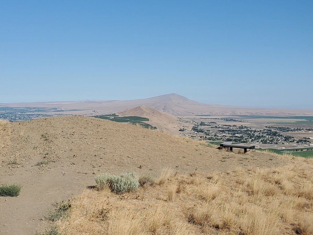
Jump Off Joe
Jump off Joe is a butte in the Horse Heaven Hills south of Kennewick in the U.S. state of Washington7https://en.wikipedia.org/wiki/Jump_Off_Joe_(Washington). It rises above the Tri-Cities and is visible throughout much of the region, including in parts of Umatilla and Morrow Counties in Oregon to the south. A gravel road approaches the summit from the south up a steep incline. On a clear day, visitors to the summit can see Mount Hood, Mount Adams and Mount Rainier
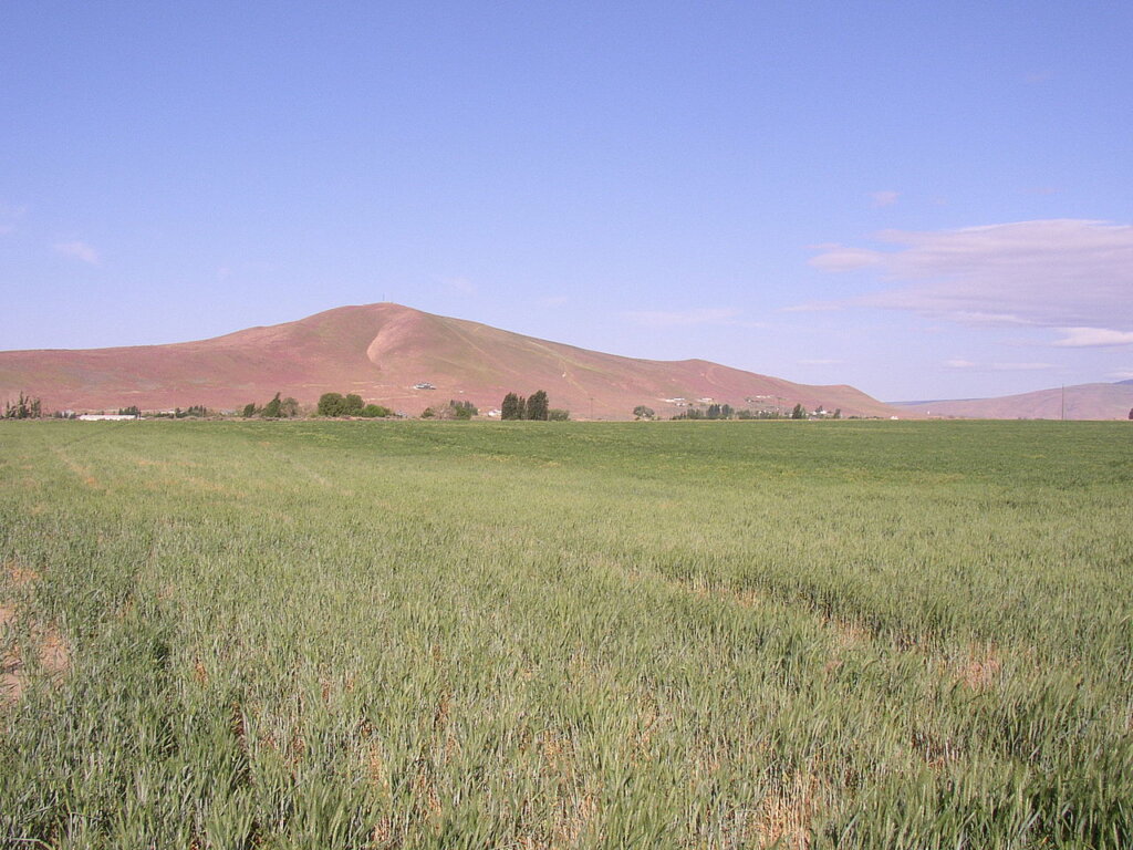
Badger Mountain
Badger Mountain is a small mountain in Richland, Washington8https://en.wikipedia.org/wiki/Badger_Mountain_(Benton_County,_Washington). Badger rises above the Tri-Cities connected to the smaller Candy Mountain via Goose Gap, is visible throughout much of the area and is a popular hiking destination for a wide variety of climbers. There are a number of trails climbing the mountain with varying levels of difficulty. Most of Badger Mountain is protected by the Badger Mountain Centennial Preserve, but the radio towers at the peak are private property. There are two summits on Badger Mountain, named the East Summit and the West Summit. The West Summit is the highest.


Candy Mountain
Candy Mountain is a small mountain located just outside West Richland, Washington9https://en.wikipedia.org/wiki/Candy_Mountain_(Washington). Candy Mountain rises above the Tri-Cities, located between Badger Mountain to the south and Red Mountain to the north.
Red Mountain
Red Mountain is located in the southeast corner of Washington state near the Tri-Cities between Rattlesnake Mountain and Candy Mountain10https://en.wikipedia.org/wiki/Red_Mountain_(Benton_County,_Washington). This region is situated among the Columbia, Snake and Yakima Rivers. The mountain covers an area of approximately 4,040 acres (16.3 km2).
National Protected Areas
Hanford Reach National Monument (Part)
The Hanford Reach National Monument is a national monument in the U.S. state of Washington11https://en.wikipedia.org/wiki/Hanford_Reach_National_Monument. It was created in 2000, mostly from the former security buffer surrounding the Hanford Nuclear Reservation. The area has been untouched by development or agriculture since 1943. Because of that it is considered an involuntary park.


Manhattan Project National Historical Park (Part)
Manhattan Project National Historical Park is a United States National Historical Park commemorating the Manhattan Project that is run jointly by the National Park Service and Department of Energy12https://en.wikipedia.org/wiki/Manhattan_Project_National_Historical_Park. The park consists of three units: one in Oak Ridge, Tennessee, one in Los Alamos, New Mexico and one in Hanford, Washington.


Umatilla National Wildlife Refuge (Part)
The Umatilla National Wildlife Refuge is located on and around the Columbia River about 15 miles (24 km) northwest of Hermiston, Oregon and includes 8,907 acres (3,605 ha) in Oregon, and 14,876 acres (6,020 ha) in Washington13https://en.wikipedia.org/wiki/Umatilla_National_Wildlife_Refuge. It was established in 1969 to help mitigate habitat lose due to the flooding that occurred following the construction of the John Day Dam. The refuge is popular with birdwatchers and wildlife enthusiasts.